Overview
Ships are military units you can place on the map. Each ship belongs to a class (for example Type 055, Arleigh Burke or Kuznetsov), which provides default data for its movement, weapons and sensors.
The map currently includes ships from four countries: China, Iran, Russia and the United States. The catalog covers aircraft carriers, cruisers, destroyers, frigates, corvettes, patrol boats, amphibious ships and submarines.
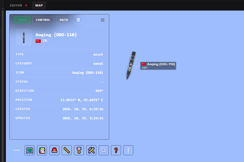
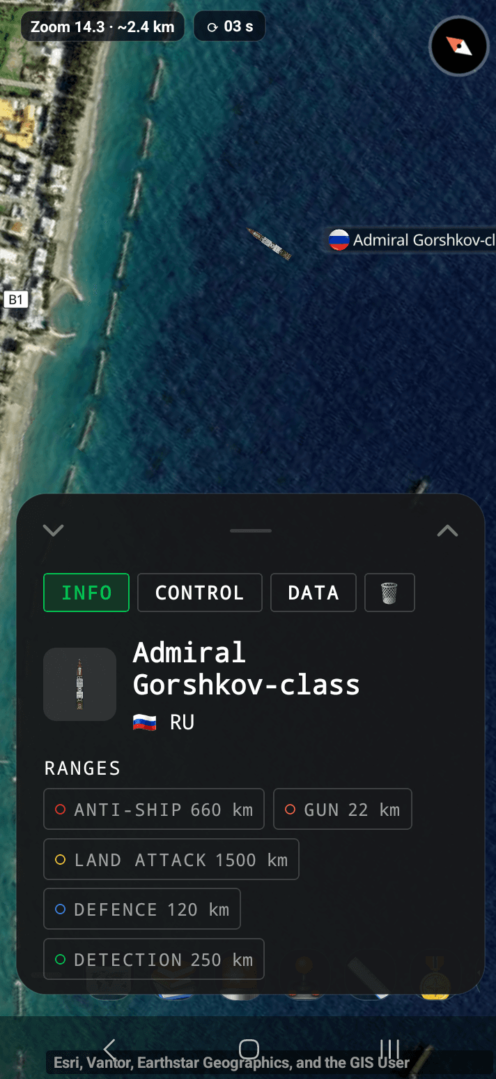
In the app the panel looks like the screenshot on the right: the RANGES switches sit at the top of the INFO tab, above the ship's basic details.
With a ship you can:
- move it across the map using its available movement data, including acceleration, braking and turning;
- display weapon, air-defence and radar ranges as circles on the map;
- open its panel to view and edit its available data.
Class data is approximate and describes a typical ship of that class, not necessarily every individual vessel. You can edit the available data for an individual ship in its panel.
Quick start
The shortest path from an empty map to a moving ship with its ranges on display:
Switch on Military Units
Turn on the Military Units layer, otherwise ships are not drawn on the map.
Place a ship
In the app, use the Units panel. On the web, use the ASSETS tab of the Command panel and pick the Naval filter. Choose a country and a ship class, then place it on the map.
Open its panel
Tap the ship. The panel opens on the INFO tab, with the three tabs INFO, CONTROL and DATA at the top.
Show its ranges
In INFO, tap a RANGES switch, for example ANTI-SHIP or DEFENCE, to draw that circle around the ship.
Send it somewhere
In CONTROL, enter a latitude and a longitude under Go to and press Go. The ship accelerates and sails there in a wide arc.
Correct what you know better
In DATA, tap the pencil next to a value, such as max speed or a weapon range, and enter your own number.
Placing and selecting a ship
Ships appear on the map when the Military Units layer is switched on.
In the app, to add a ship, open the Units panel from the map toolbar, pick a country, then choose a ship from the naval vehicles. Give it a name, and a description if you want one, then tap the map where it should go. Before you confirm, you can rotate the icon to the direction the ship is facing and adjust its size with the slider.
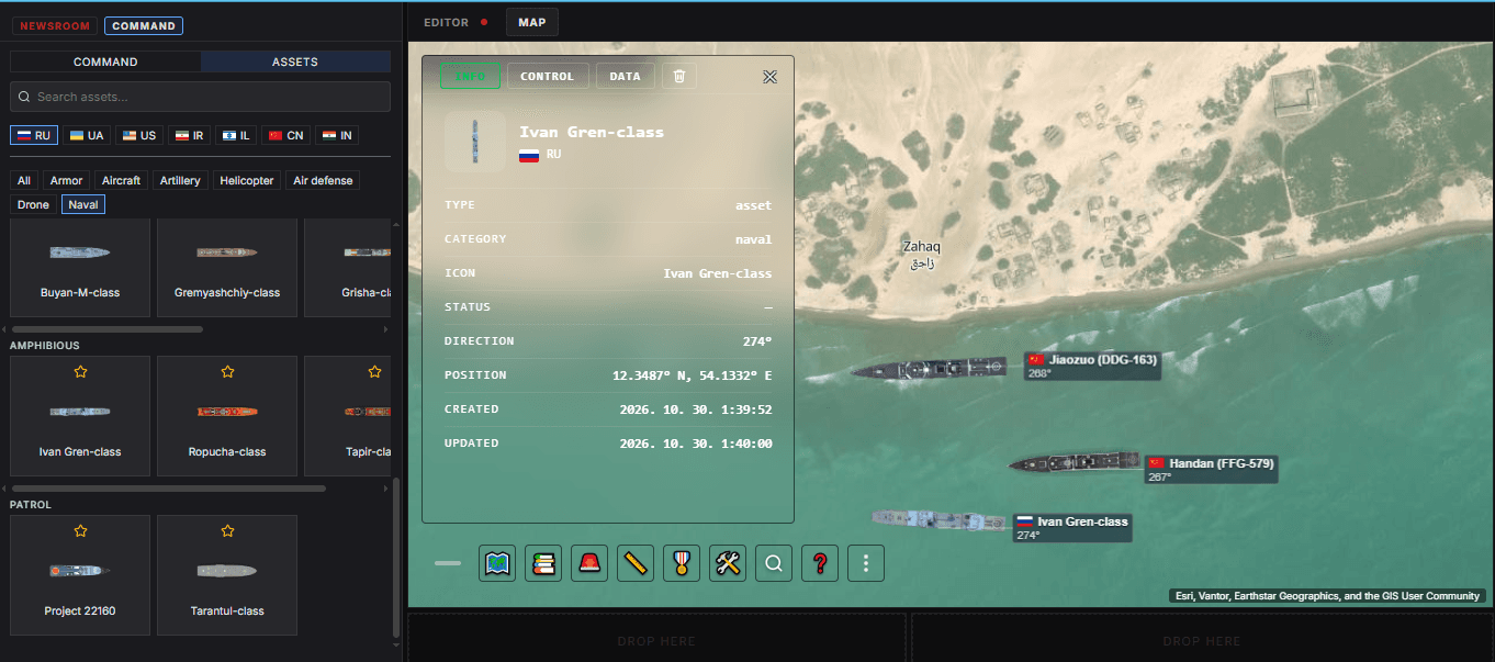
On the web, open the Command panel and switch to the ASSETS tab. Pick a country, choose the Naval filter, then click a ship class to add it to your selection (some classes open a list of named ships). A bar shows how many ships are selected. Click Click on map and then click the map to place them, or open Coordinates, enter a latitude and a longitude and press Place at coordinates. Clear empties the selection.
Ship icons are scaled to the real length of the class, so a carrier looks much longer than a patrol boat.
To select a ship, long-press its icon on the map. Long-press more icons to select several ships at once. A short tap on a ship opens its panel, which has three tabs: INFO, CONTROL and DATA.
The ship panel
Tap a ship to open its panel. It has three tabs, INFO, CONTROL and DATA, and a trash button that removes the ship from the map (in the app you tap it twice to confirm).
INFO
INFO shows the ship's basic details: type, category, icon, status, direction, position, when it was created and last updated, and the description if you wrote one.
At the top of the tab are the RANGES switches: ANTI-SHIP, GUN, LAND ATTACK, DEFENCE and DETECTION. Tap a switch to show or hide that range circle on the map. A switch appears only if the ship has data for its category, and all circles are off by default. What each circle means is explained in Range circles below.
CONTROL
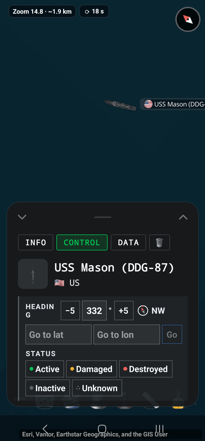
- Heading — the direction the ship faces. Type a value, use the −5 and +5 buttons, or open the compass dial. While the ship is moving, the field sets the final heading, the direction it faces when it arrives.
- Go to — enter a latitude and a longitude and press Go (or Enter) to send the ship to that point. This sets the destination only. There is no separate speed command: the ship's speed follows its movement data.
- Status — Active, Damaged, Destroyed, Inactive or Unknown. Tap the selected status again to clear it.
The screenshot below shows the CONTROL tab in the app: the heading field with its −5 and +5 buttons and the compass shortcut, the Go to fields with the Go button, and the status buttons.
DATA
DATA lists the ship's movement values, weapons and sensors.
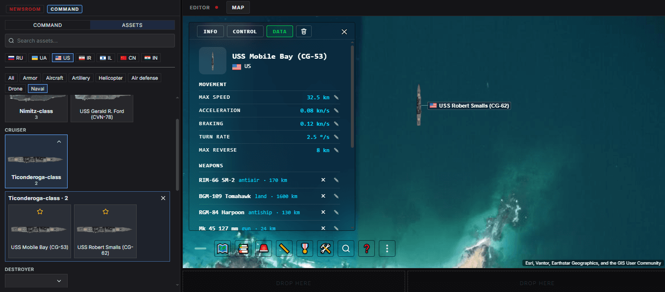
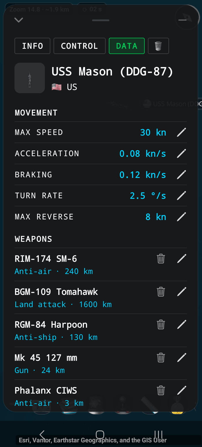
In the app, shown on the right, every movement value and every weapon or sensor row has a pencil at its right end. Weapon and sensor rows also have a trash button to remove them.
- MOVEMENT — max speed (kn), acceleration (kn/s), braking (kn/s), turn rate (°/s) and max reverse (kn). A ship uses its detailed movement only when max speed, acceleration, braking and turn rate are all set.
- WEAPONS and SENSORS — each row has a name, a category or type, and a range in km.
To edit a movement value, tap the pencil next to it, type the new value and press Enter or leave the field. A value outside the allowed range shows a message and is not saved. For a weapon or sensor, the pencil opens the whole row: name, category, range and source. The tick saves and the cross cancels.
Use + ADD WEAPON or + ADD SENSOR to add a row, and the trash button on a row to remove it (in the app a second tap confirms).
Reset to class appears once you have changed something. The first press asks for confirmation, the second restores the class defaults for this ship's movement, weapons and sensors.
Your changes apply only to this ship. The ship class and other ships of the same class keep their default values.
How ships move
To move a ship, use Go to in the CONTROL tab, or select it and tap a point on the map. The ship then sails to the destination using the movement values in its DATA tab.
- Speed — the ship cannot go faster than its max speed. It speeds up slowly, at its acceleration, and slows down at its braking value. A ship with a low braking value needs more distance to stop.
- Turning — a ship cannot turn on the spot. It sails in an arc whose size depends on its speed and turn rate: the faster it goes, or the lower its turn rate, the wider the arc.
- Reversing — a ship reverses only if a max reverse value is set, and only for a nearby target behind it. Otherwise it turns and sails forward.
- Arrival — if you set a final heading, the ship faces that direction when it arrives.
- Groups — ships and other units sent together move as a column, at the speed of the slowest unit with detailed movement data.
If a ship is missing max speed, acceleration, braking or turn rate, it does not use this movement. It falls back to a simple move with a fixed duration and no gradual speed change. Fill in the missing values in the DATA tab to get the full behaviour.
Range circles
A range circle is drawn on the map around the ship, with the ship at its centre. It shows how far a kind of weapon or radar on that ship reaches. Switch the circles on in the RANGES section of the INFO tab.
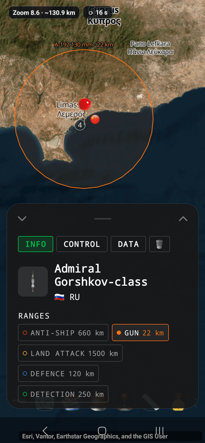
The screenshot on the right shows the GUN switch turned on: the orange circle is the ship's longest gun range, and the label on the circle names the gun and its range.
- ANTI-SHIP (red) — the longest anti-ship missile range.
- GUN (orange) — the longest gun range.
- LAND ATTACK (yellow) — the longest range against land targets.
- DEFENCE (blue) — the longest air-defence missile range, the zone the ship can cover against air threats.
- DETECTION (green) — the longest radar range, how far the ship can see.
Each category shows one circle, for the system with the longest range in that category. It is not a separate circle for every weapon, so shorter-range weapons of the same kind, such as close-in defence guns, are not drawn. A label on the circle names that system and its range, for example the missile name and 180 km.
A circle shows the nominal maximum range of the system. It does not mean the ship can hit or detect every target inside it. The real reach depends on the target, the conditions and the targeting data.
The circles follow the ship while it moves. The ranges come from the ship's DATA tab, so if you change a range there, the circle changes with it. Submarine torpedoes and sonar do not have a circle yet.
Examples
Compare the reach of two ships
Place a Chinese Type 055 and an American Arleigh Burke some distance apart. Open the INFO tab of each and switch on ANTI-SHIP and DEFENCE. The circles show at a glance which ship's anti-ship missiles reach further and how large an area each one can cover against air threats. Keep in mind that these are nominal ranges, not guaranteed combat distances.
Watch how different ships handle
Place an aircraft carrier and a corvette at the same point and send each one to the same destination with Go to in its own CONTROL tab. The corvette picks up speed and turns much faster. The carrier needs a long time to accelerate and sails a wide arc. If you select and send them together, they move as one column at the speed of the slower ship.
Correct a value you know better
If a reference gives a different range for a weapon, open the DATA tab, tap the pencil on that weapon's row, change the range and save with the tick. The matching range circle changes with it. Reset to class brings the default back whenever you want.
Ship classes by country
Each class has its own default movement, weapons and sensors. Some classes also list named ships, for example the Nimitz-class carrier USS Abraham Lincoln.
- China — aircraft carriers Liaoning, Shandong and Fujian; destroyers Type 052C, 052D, 055 and 956; frigates Type 054, 054A and 054B; corvette Type 056; amphibious ships Type 071, 075 and 076; air-cushion landing craft Type 726.
- Iran — Zolfaghar fast attack craft.
- Russia — aircraft carrier Admiral Kuznetsov; cruisers Kirov and Slava; destroyer Sovremenny; frigate Admiral Gorshkov; corvettes Steregushchiy, Gremyashchiy, Buyan-M, Karakurt and Grisha; Tarantul missile boat and Project 22160 patrol ship; landing ships Ivan Gren, Ropucha and Tapir.
- United States — aircraft carriers Nimitz and Gerald R. Ford; cruiser Ticonderoga; destroyer Arleigh Burke; amphibious assault ship Wasp; littoral combat ship Independence; submarines Los Angeles and Ohio.
Data and accuracy
The values in a ship's DATA tab are class defaults. They describe a typical ship of the class, not one specific vessel. Values are approximate estimates for a typical ship of the class, based on the type of ship and publicly available information, and have not been checked against official specifications.
The panel does not mark which values are estimates, so treat every class value as approximate. They are good enough to show how a ship behaves and what it can reach, but they are not official specifications.
If you know a better value, enter it in the DATA tab. It is saved for that ship only, and Reset to class brings the default back. Changing a value on one ship does not change the class or other ships.
Terms used in the panel
- Knot (kn) — one nautical mile per hour, about 1.85 km/h. Ship speeds are given in knots.
- kn/s — how many knots the speed changes every second. It is the unit of acceleration and braking.
- Turn rate (°/s) — how many degrees per second the ship can change its heading. Together with its speed it decides how wide the ship's turning arc is.
- Heading — the direction the ship faces, in degrees from north: 0 is north, 90 is east, 180 is south and 270 is west.
- Range (km) — the nominal maximum distance a weapon or sensor reaches.
- Anti-ship missile — a missile used against other ships.
- Land-attack missile — a missile used against targets on land.
- Air-defence missile — a missile that protects the ship and nearby ships against aircraft and missiles.
- CIWS — close-in weapon system, a rapid-fire gun that defends against incoming missiles at very short range.
- Radar — detects air and surface targets. The DETECTION circle shows the longest radar range.
- Sonar — detects targets under water. It has no range circle yet.
Limits
- No coastline check — the map does not know where the water is. A ship can be sent over land or through shallow water.
- No speed command — Go to sets the destination only. The ship's speed follows the movement values in its DATA tab.
- No combat — ships do not fire or engage. Weapon and radar ranges are for reference on the map.
- Range circles — each category shows one circle. Torpedoes, anti-submarine weapons and sonar have no circle yet, and close-in defence weapons are not drawn when a longer-range system exists in the same category.
- Approximate data — class data is an estimate, and the ship models show a typical vessel, not a specific one.
Frequently asked questions
Why does my ship move at a constant speed instead of speeding up?
The ship is probably missing one of max speed, acceleration, braking or turn rate. Without all four it uses a simple fixed-duration move. Fill in the missing values in the DATA tab.
Why can a ship sail over land?
The map does not check the coastline. A ship goes to the destination you give it, even if that point is on land or in shallow water.
Why is there no circle for sonar or torpedoes?
Circles exist for anti-ship, gun, land-attack, air-defence and radar ranges. Torpedoes, anti-submarine weapons and sonar do not have a circle yet.
If I change a value, does it change every ship of that class?
No. A change applies only to the ship you edited. The class and other ships of the same class keep their default values, and Reset to class restores the defaults for this ship.
Can I set the speed when I send a ship somewhere?
Not separately. Go to sets only the destination, and the ship's speed follows the movement values in its DATA tab.